


The young boy, possibly 8 or so, sat cross-legged in the middle of the white stone “beehive” hut. He spoke quietly but intently to a young girl, probably his sister, sitting directly across from him.
Suddenly, a woman stepped into the igloo-shaped structure. “We have to go; it’s time to start heading down,” she said to the boy, who was decked out in a brown robe.
“But, Mom,” wailed the junior Jedi. “We’re re-enacting a scene!”
Fortunately, Mom wasn’t heartless enough to yell “cut.” So she nodded and stepped back outside. A few minutes later, the two Star Wars aficionados traipsed after her, undoubtedly reveling in the excitement of visiting Luke Skywalker’s secret retreat and reliving a moment from “The Last Jedi.”
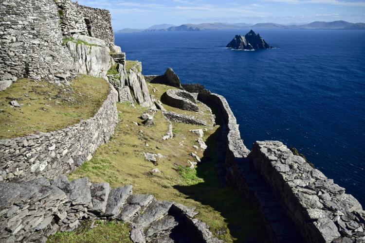
The young American was the only Jedi I spotted on Skellig Michael that day; the robe, of course, was a dead giveaway. But I suspect that others also came primarily to see Luke Skywalker’s hideaway, an astonishing monastery, reportedly built in the sixth century, pillaged by Vikings in the ninth century and ultimately abandoned in the 12th century. Me? I was there for both.
People are also reading…

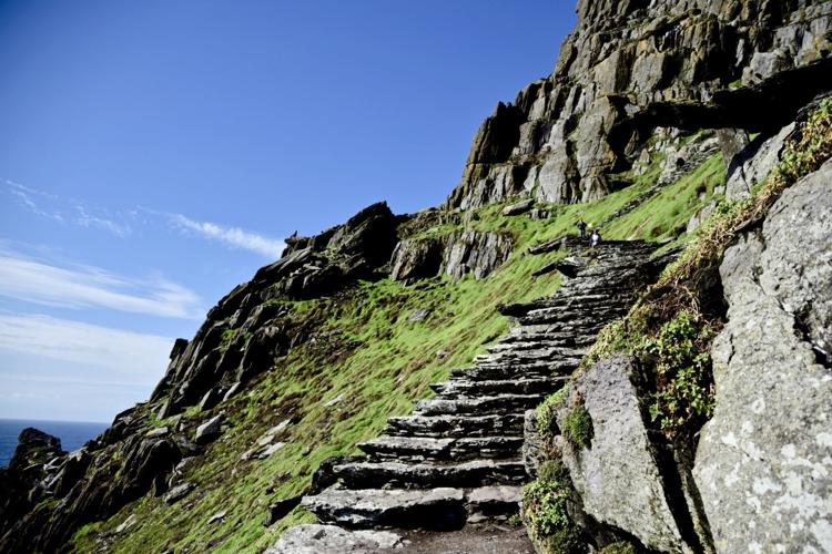
Visitors to Skellig Michael, an old Christian monastery, must climb 600 steps to reach the top. Photo by Susan Hegger.
And I was lucky to be on the top of this rather forbidding rock jutting from the sea. Much like Rey, we overcame several daunting obstacles to visit this UNESCO World Heritage Site.
First, only 180 people are allowed on the island each day. Boats to Skellig Michael run from March to October out of the small town of Portmagee on the Ring of Kerry in western Ireland. The boats are small, each holding about 12 passengers. Reservations are essential. I went through four boat companies before I found three seats available any time in the four-day window we had in Kenmare — and I was searching a month and half in advance.
Having tickets, though, is just the first step. The second hurdle is the weather, especially the condition of the ocean. If the seas are choppy, it’s a no-go. We had a sunny day, but the captain told us that stormy weather had forced the cancellation of most trips the week before us. He estimated his boat goes out only about 90 times a year.
The third obstacle is the island itself. Visitors need to be in good condition to mount the 600 steps — no railings! — to the top. And, of course, what goes up must come down. We brought our trusty hiking poles, and they helped with both the ascent and descent.

Our first views of the rocky island of Skellig Michael came during a drive on the Ring of Kerry. Photo by Susan Hegger.
Luckily, the Force was most definitely with us that day. The sun beamed and the waters were calm as we sailed first around Little Skellig, where we could marvel at the thousands and thousands of gannets that made it their home. (We were too late for the puffins.) Then we sailed around Skellig Michael itself before we disembarked, basically by jumping from the boat onto a concrete landing, with an assist from one of the crew.
Fortunately, the rough-hewn steps to the top were dry. Once at the top, a docent regaled us with the history of the monastery. Ultimately, though, I wanted time to see the small cemetery; to explore the primitive, stone “beehive” huts, which housed the monks’ cells, church and oratorio (similar beehives can be seen on the Dingle peninsula); and just to ogle at this incredible scene. No wonder its strange, stark beauty captivated the makers of “Star Wars.”
Anybody seen Jon Snow?
The road to King’s Landing, aka Dark Hedges, was devilishly hard to find. We were in the middle of nowhere in County Antrim, Northern Ireland, driving on narrow country lanes that we joked were just a cow and half wide. Google Maps kept directing us to a particular road, unaware of its closure due to roadwork. We detoured repeatedly and were rerouted repeatedly until finally we saw several cars parked on the side of a road.

Dark Hedges, a tree tunnel of birch trees, was used as a road to King’s Landing in the popular TV show “Game of Thrones."
This has to be it, I thought. Why else would there be so many cars?
We walked about a quarter mile up Bregagh Road, and there it was: an avenue of tall beech trees, their twisty, gnarly limbs forming a tree tunnel. Couples, individuals and groups meandered the roughly half-mile stretch of road (now closed to traffic), soaking up the mysterious ambiance and admiring the eerie arch of branches.
The Stuart family originally planted the trees in the 18th century to make a dramatic impression as visitors approached their Gracehill manor house. But since its use as a location in “Game of Thrones,” Dark Hedges has become wildly popular. (Indeed, tourism authorities in Northern Ireland have built on the popularity of “GoT” and have helpfully erected signs identifying “GoT” locations. Websites also list various “GoT” locations, and tour companies offer “GoT” itineraries.)

Ballintoy Harbor, on the coast of Northern Ireland, became the Iron Islands on “Game of Thrones." Photo by Susan Hegger
The next day, as we drove the scenic Causeway Coastal route, we veered off to see Ballintoy harbor. It was a steep ride down a narrow road, and as we neared the bottom, I gasped. I had seen this picturesque harbor before — in a dramatic photograph in a gallery near our bed-and-breakfast in Portrush. As we wandered about taking our own photos, I discovered a sign identifying the harbor as the spot where Theon Lovejoy returned to the Iron Islands, his home.

The Carrick-a-rede rope bridge is 66 feet long and 98 feet high above the rocks. From the bridge, one can see the Larrybane quarry, another “Game of Thrones” site, in the side of the cliffs. Photo by Susan Hegger
We didn’t visit Larrybane quarry, where viewers first meet Brienne of Tarth, but we could see it from the Carrick-a-Rede rope bridge (which itself can be seen in the distance in that “GoT” scene). The original bridge was built in 1755 and connected the mainland to an island with a salmon fishery (now closed). The current bridge is 66 feet across and 98 feet above the rocks and water. And, yes, it sways as you cross — and that’s a big part of the excitement. Once you cross, there’s not much to explore. Much of the trail on the island was closed when we were there.
The coast around the rope bridge is free to explore, but there’s a small charge to cross the bridge. Guidebooks and information at the ticket booth caution against people with vertigo or fear of heights from crossing. Frankly, the warnings seemed a little exaggerated to me. I thought that scariest part was the steep, open metal staircase leading down to the bridge.

Giant’s Causeway, a Unesco world heritage site, is made up of roughly 40,000 basalt columns. Photo by Susan Hegger.
Strangely, one of the most otherworldly places we visited — Giant’s Causeway in County Antrim, Northern Ireland — is not a location in “Game of Thrones” (or “Star Wars,” for that matter). Created by volcanic action, the causeway is made up of about 40,000 massive black basalt columns extending into the sea.
The name comes from a legend, which tells of a contest pitting the rather puny Irish giant Finn MacCool against a big Scottish giant who lived on Staffa, an island of basalt columns we had visited a couple of years ago. Staffa and the causeway are apparently part of the same geological formation, and we were impressed that the connection is immortalized in legend.

The Giant’s Causeway, comprised of thousands of basalt columns, was created by volcanic activity more than 60 million years ago. Photo by Susan Hegger.
Those in a hurry can take a bus from the visitors center to the causeway. In a little less of a hurry? Walk the half mile or so from the visitors center to the causeway.
But those with time — like us — should opt for the red trail, a cliffside path with spectacular overhead views of the causeway. The path then drops down and about midway down, one can detour to see various other formations, like the “organ,” basalt columns that evoke organ pipes.
It was while we were exploring this tangent of the red trail that we got drenched by a sudden, violent storm. We tried to shelter under a rock overhang, but when the rain showed no signs of abating, we decided to take our chances and leave. As suddenly as it appeared, the storm ended. By the time we reached the causeway, the dark clouds had moved out to sea.
The old Old World
Ireland’s dramatic landscapes and volatile weather make it easy for the island to conjure up and beguile us with distant planets, fantasy worlds and Celtic legends.
But when it comes to the mysterious and enigmatic, Ireland doesn’t need fiction. There’s plenty of mystery and awe in the remains of its own ancient past.

Newgrange, a Neolithic passage tomb, is more than 5,000 years old. On the winter solstice, sunlight enters the passage and illuminates the inner chamber. Photo by Susan Hegger
About 45 minutes north of Dublin is Newgrange, a Neolithic passage tomb built around 3200 B.C., making it older than the Egyptian pyramids or Stonehenge. (It can be visited only on a guided tour. Timed tickets are sold at the visitors center.)
At the entrance is a large stone, decorated with stone spirals, a common motif. The passage into the tomb is low and narrow; we ducked and held our purses and cameras in front of us so they wouldn’t scrape the walls. Once inside the inner chamber, we saw three niches where the communal burials were. Geometric carvings adorned some stones.
The “highlight” came when the guide turned off the lights, and we were in complete, utter darkness. Then she flipped a switch, and we experienced what it would be like inside the tomb, which is believed to have also been used for rituals, on the winter solstice. On that day alone, the light of the rising sun enters the passage and illuminates the inner chamber for 17 minutes.
In County Clare, in the famed Burren, a lunar-like limestone plateau, we visited the Poulnabrone dolmen, a portal tomb in use between 5,200 and 5,800 years ago. The tomb sits on a high spot, so it is easily seen from the road, and it exerts a primitive attraction. What made the site special, at least for me, was the setting: the austere limestone “pavement” that emphasized the loneliness and the solitude of the tomb. (Incidentally, the famous Cliffs of Moher are on the edge of the Burren region.)
Among its various stops, the renowned Ring of Kerry drive has three stone ring forts to visit — Staigue (near Sneem), Cahergall and Leacanabuaile (both near Cahersiveen). These are circular fortresses, mainly dating back 300 to 600 A.D. Also called fairy forts, they are thought to have been defensive structures built around farmsteads. All three on the Ring of Kerry are worth visiting; each is a little different.

Dun Aengus, an ancient ring fort, was built on the edge of 300-foot cliffs on the island of Inishmore.
One of the most amazing stone forts, though, is Dun Aengus on the island of Inishmore, one of the Aran islands. In part that’s because of its age (built about 1100 B.C. and occupied until roughly 1000 A.D.) and size (consisting of several concentric walls). But mostly, it’s because of its breathtaking location — right smack on the edge of 300-foot cliffs.
The day we were there was gray and a little drizzly. It didn’t take much wind to let you know you could be swept right off the cliffs and knocked onto the rocks below. Maybe that’s why I got a little dizzy as I neared the precipice.
Skellig Michael, Newgrange, Poulnabrone dolmen, Dun Aengus, the Ring of Kerry— all these were places that we had long planned to visit. Like Giant’s Causeway and Carrick-a-rede, they were part of a detailed itinerary.
Sometimes, though, serendipity strikes, and you come upon something by surprise. Driving the Ring of Beara, we saw a sign for a stone circle. We drove, drove and drove some more — we were on the verge of giving up — when we came upon a small parking lot and an honor box for the 2 euro entry fee. Despite the rain, I grabbed the camera and headed up a hilly path, in search of the circle. My two companions stayed in the car.

The Uragh stone circle on the Beara peninsula is thousands of years old. Photo by Susan Hegger.
Finally, I came upon what I later learned was the Uragh stone circle and my jaw dropped: five stones in a tight circle, one megalith about 10 feet tall. In the background, framed by the stones, a waterfall roared.


